Back from Arizona and Colorado, where I visited family and friends in Phoenix and Colorado Springs. I didn’t spend much time on the internet. I had an opportunity to read Anthony’s interesting new posts on more stations. Each new station seems to yield an interesting story. It is disquieting that the USHCN site with the greatest relative temperature increase (University of Arizona – Tucson) is both located in a parking lot and operated by a university science department (Malcolm Hughes of MBH is also at the University of Arizona). I traveled through Phoenix airport (which is a GHCN, GISS, Parker and probably CRU site) and, while I did not have a chance to locate the weather station, it will not surprise readers that Phoenix Sky Harbor airport is a big urbanized airport. We went to Sedona on a day trip and the tourist brochures said that the Sinagua Indians abandoned the area in the 1400s – something that might be related to climate and which might be worth following up on another occasion.
I took the occasion of my visit to Colorado to specifically visit some bristlecones in the Mt Almagre area west of Colorado Springs (thanks to CA reader Pete Holzmann), together with our wives and my sister. I’ll write a few posts about bristlecones over the next couple of weeks, including photographs and a really neat Google Earth itinerary of our trip up Almagre, including a discussion of the Starbucks hypothesis (whether a dendrochronologist can have a latte in the morning and still carry out a sampling program). We reached a little higher elevation than the Sheep Mountain CA bristlecones (which are about one degree further south) and were still below treeline. There are a number of ways to reach treeline in different parts of Colorado, one of the more interesting being the Pikes Peak climb, for which practice runs were taking place during our visit.
We also spent a couple of days in Breckenridge, a ski resort at 10 000 feet about 2 hours west of Colorado Springs. We had an interesting drive across the continental divide and through South Park, so I had an opportunity to see quite a few panoramas showing high-altitude treelines. Upper border treelines are supposedly required in order to obtain temperature proxies from ring widths, so it was interesting to see so many treeline vistas.
Having stood on a hill at 11 400 feet ( a little higher than Graybill’s Sheep Mt samples) which was below local treeline of 11,800-11,900 feet, it made me wonder a little about why the Sheep Mountain CA treeline is so low. Also the competition between trees at Colorado treeline appears to be different than in California: in California, bristlecones compete with big sagebrush, while in Colorado, both Engelmann spruce and bristlecones occur at high altitudes and presumably compete. It would be interesting to know what governs the competition between them and why the competition is different than California. It would be nice to see maps describing the competition, but I’ve not seen any, despite the importance placed on this data for climate reconstructions. High-altitude bristlecone sites actually appear to be more prevalent in Colorado than in California and it is more than a little disappointing that no high-altitude collections in Colorado have been updated in over 15 years.
So there are a number of things to talk about. Today, I want to do a brief survey, scoping high-altitude sites in Colorado and elsewhere. I’ll also make some comments on Pike’s Peak (which is also to the west of Colorado Springs, just to the north of Almagre), which was the site of the annual Pike’s Peak Hill Climb on July 21.
Colorado High-Altitude Sites
Here are some particulars about high-altitude Colorado sites:
- 24 series (18 sites) from above 3200 m (10 500 ft), of which 20 are ring width and 4 density (the 4 density series all also from sites with RW series). There are 5 series (4 sites) above 12 000 feet (3 658 m); an additional 7 series between 11 500 and 12 000 ft) (3506 – 3658 m); 7 series between 11 000 and 11 500 feet (3353-3506 m) and 5 series between 10 500 and 11 500 ft (3201-3353 m).
- two series were collected by Lamarche in the 1960s; one series by Hansen-Bristow in the 1970s; 16 series in the 1980s (Graybill -8; Schweingruber- 8; Kienast -2); only three in the 1990s (Diane Douglas -2; Peter Brown and Connie Woodhouse -1) and none in the 2000s.
- There are 3 limber pine (PIFL) series (all between 10 500 and 11 000 feet), 14 Engelmann spruce (PCEN) series and 7 bristlecone pine (PIAR) series, with both Englemann spruce and bristlecone occurring above 11 500 feet. There are no samples later than 1994.
- two archives of the Almagre PIAR series, one from Lamarche in 1968 and one from 1983, the 1983 edition including approximately half of the 1968 cores (re-numbered). There are 2 Niwot Ridge PCEN versions, a 1979 edition at 3700 m from Hansen-Bristow and a 1982 edition at 3400 m from Schweingruber. (There is a third Niwot Ridge version, a PIFL version at 3100 m from Graybill taken in 1987). So altogether about 18 distinct sites have been sampled.
As noted above, in the Colorado Springs area, the treeline looked like it was at about 11,800-11,900 feet as the summit of Mt Almagre (12 200 feet) is above treeline at his peak. Treeline must be a little higher in some other locations, as samples are reported from around 3 700 m (12 146 m) (Engelmann spruce at Cottonwood Pass and Niwot Ridge and bristlecones at Blanca Peak. I don’t know how close to treeline a site has to be to be a an “upper treeline” site in Rob Wilson’s eyes (I’ll ask him), but many “high-altitude” sites in Colorado are not necessarily at the upper treeline. Graybill’s Frosty Park PIFL series said to be at 10,500 feet would be well below the Mt Almagre treeline.
In a worldwide context, the Colorado sites constitute a surprisingly large proportion of the all high-altitude sites. WDCP has a search function, which interested parties may consult. I identified a total of only 24 sites above 3506 m (11 500 ft), of which 12 were from Colorado and northern New Mexico (the two New Mexico sites were contiguous to soutghern Colorado and were collected by Lamarche series in 1968). There was one site from Germany (Kreuth – two series) collected in 1961; one site from Mexico (collected by Biondi in 1997), one site from China (a juniper site from Wulan near Dulan collected in 1986), two sites from California-Arizona (one Graybill from the 1980s and one Graumlich from the early 1990s) and 4 Nepal sites (6 series), of which 2 were collected in 1978 and the others in the 1990s.
So Colorado sites represent a surprisingly large proportion of the world inventory of high-altitude sites. Esper has reported the collection of high-altitude sites in the Tien Shan in Asia, but Esper does not archive his results. At present, it is therefore impossible to make any scientific comments about Esper’s work. (In passing, I notice that Rob Wilson and Brian Luckman made their first archives at WDCP on July 17, 2007 – I’ll assess this information on another occasion.)
Pike’s Peak and the Starbucks Hypothesis
Obviously virtually all of the Colorado corpus of high-altitude sites, like too many other proxy collections, were made in the 1970s and 1980s. People encountering the proxy reconstruction literature for the first time (including me, when I first encountered this literature) are typically amazed at the staleness of many proxy collections and wonder – wouldn’t it be a good idea to bring the proxies up to date? In the early days of the Hockey Stick debate, a realclimate reader asked this question and Mann snickered that it was necessary to use stale proxies because the updating of the collections required heavy equipment and trips to out of the way places.
Last year, I satirized this with good cause. UCAR world headquarters are in Boulder, Colorado, where UCAR fronted the IPCC Working Group 1 secretariat. NOAA has important operations in Colorado – the Chairman of IPCC Working Group 1 and the director of the WG1 TSU were both NOAA employees located in Colorado. The University of Colorado and Colorado State University all have substantial climate research programs. So there’s no shortage of climate scientists in Colorado. Despite Mann’s protestations, it seemed quite plausible to me that a climate scientist could update these collections without even having to skip a morning latte at Starbucks.
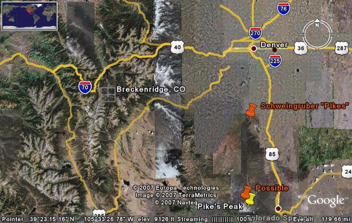
One of the high-altitude Colorado sites is a Schweingruber Engelmann spruce chronology said to be from 11800 feet at 39 20N and 105 2W, a site designated as Pike’s Peak. As noted above, there is an annual race up Pike’s Peak, which took place on July 21, 2007. You can see some interesting footage of the trip up past treeline on Pike’s Peak at youtube here
http://www.youtube.com/watch?v=nMN4zaclgrg&mode=related&search= http://www.youtube.com/watch?v=MSrDD3tcibU&mode=related&search=
It’s quite possible that one can glimpse Schweingruber’s site off to the side of the road just before treeline is reached. So an enterprising dendrochronologist interested in updating the 1983 series could perhaps hitch a ride up with one of the Hill Climb teams. Alternatively, the dendrochronologist could join in the run up and down Pike’s Peak which takes place annually. Or he could take the cog railway or he could even just drive up the road. Two of my sisters have been up Pike’s Peak, as has my grandfather (about 80 years ago). So it shouldn’t be all that hard for a UCAR climate scientist to update the Schweingruber Engelmann spruce chronology on Pike’s Peak, notwithstanding Mann’s imprecations to the contrary.
Now there’s one interesting little hitch to identifying the location of the Schweingruber “Pike’s Peak” chronology. Schweingruber recorded the location of his Pike’s Peak site as 39 20N and 105 2W, which is about half way between Coloradp Springs and Denver and about 32 miles (55 km) away from Pike’s Peak. If Schweingruber’s site is located on the road up Pike’s Peak at about 11 800 feet, then it would be in the alternative location shown below. Perhaps UCAR scientists have been trying to locate a mystery mountain between Denver and Colorado Springs and this is the reason why they haven’t updated Schweingruber’s series.
In passing, even if the locations of dendro sites are recorded correctly, the dendro convention of only recording the latitude and longitude to the nearest minute is decidedly unsatisfactory in mountain situations, where identifying the location to within 2 km is not at all satisfactory for identifying a replicable location for an individual grove. Long before GPS became available, there were things called detailed maps, a technology routinely used by geologists and which I would recommend to dendrochronologists. The Colorado sites are typically on Forest Service land, for which excellent topographical maps exist. A geologist would routinely record a site location citing the exact Forest Service map. I’ll give an example of this for a site that we visited.


10 Comments
Steve-
My lame apologies for not contacting you and yours for your visit!
I live in Silverthorne (and Boulder), not far from Breck.
regarding your tour of proxy sites, the one I’m most familiar with is on the Mt. Evans massif, with a paved road (14 miles South of Idaho Springs, off I-70) access. It is a place famed for its ancient bristlecones. It would have been a easy detour for you, and I love playing tour guide for visitors.
Your are precisely right to contrast official inertia with the easy availability to collect and update the relevant high altitude data. One simply has to wonder if neglecting data isn’t a conscious institutional policy. As you have amply demonstrated, it has gone well beyond being curious or funny. It is tragic.
In a topical related note, Storm World author Chris Mooney speaks Tuesday afternoon at NCAR in Boulder. Anyone with well-formed questions I might ask, please post to the current UNTHREADED thread.
Steven, the WDCP link is to
http://www.climateaudit.org/www.ncdc.noaa.gov/paleo/
but should be to
http://www.ncdc.noaa.gov/paleo/
Steve,
Glad you’re back, though Anthony did a fine job keeping things running in your absence.
I’m also glad the site’s back up thought I don’t see any new messages yet so I’m wondering if everything is going into the spam filter just now.
There is a Bristlecone Pine Scenic area on Mt. Bross in Colorado which can be reached, most likely, by 2WD vehicle, although a 4WD is probably preferred. Here is a website with directions.
http://gorp.away.com/gorp/resource/us_scenic_area/co_brist.htm
I remember driving up there in the early 80’s. Beautiful site.
That site looks to be at the end of the so-called “Front Range” of which, Pike’s Peak is the dominant feature. I believe that puts you in the Larkspur area, which is almost to Castle Rock. there’s nothing even remotely close to 11,800 feet around there from what I know (Pike’s Peak is only 14,110 feet).
The drive up 24 in to Breckenridge is awesome, isn’t it? Hoosier Pass, sitting around 11,400 feet (where you stopped I assume?) is breathtaking. In the winter, the switchbacks (7 of them) are quite a challenge. Fortunately, there’s some military significance to that road so it is plowed continually and has only been closed once in something like 25 years (due to a crazed gunman that was mad at the DMV in Fairplay or Alma… really). Of course, I was stuck at the top trying to get home from a long day of skiing when said closing happened. 🙂
Mark
If a geologist misses by 2Km he will not find his mining claim i.e. exactness has value.
If a “climate scientist” misses by 2 Km well, who cares? Close enough. Besides who would ever take an interest in checking the data?
Not being physicists or geologists or chemists they have no idea of the value of precision (let alone accuracy) in the data.
As long as the paychecks keep coming and there is data to manipulate what is the difference? Besides no one will be the wiser.
Hope you had a good time here in the Springs. I was entertaining my mother last week in the Springs, and as part of it, I took the Cog Train to the summit. (It’s only $27 per person if you take the first train of the day.) About half-way up the mountain you pass the “Caretaker’s House” which sits next to the small hydro-electric power plant. Imagine my surprise to see a Stevenson Screen sitting smack dab in the middle of their yard. I grabbed some photos of it on the way back down.
Now, these people have to drive 17 miles just to get to their mailbox every morning, yet the climatologists up in Boulder can’t make the two hour drive down here to update the tree-ring proxies. Yeah, that seems right….
Rob Wilson’s new article says:
“A search through the ITRDB, found surprisingly few temperature sensitive TR data sets that came up to at least 1995.”
This is something that has been stated at CA for some time. I didn’t notice Rob agreeing with such comments here; I didn’t notice him observing to the U of Arizone listserv that he agreed with this CA comment.
Steve,
Regarding updating the record, I don’t think you really understand the difficulties.
Do you know how difficult it is to go through life, with your pockets bulging with so much grant money that you’re six feet wide?
Have you ever tried to get in a car and drive somewhere in that condition? Do you understand how it feels when people look at you like that on a cog railway?
And the Pike’s Peak run! Who are you kidding? You try walking more than 50 yards down to the tea room without getting winded, when you’ve got $1,000,000 grant cash hampering your every move.
It’s a disability, I tell ya. You people don’t take these things into consideration.
They’re doing the best they can under very trying circumstances.
When Rob Wilson says this does not he mean that a pre-selection of TR data sets would eliminate a suprising portion of the those that come up to at least 1995 — because they are, well, not temperature sensitive. It evidently becames more difficult to find the “right” data sets when searching out-of-sample.
One Trackback
[…] and I thought that it would be rather fun to test the Starbucks Hypothesis and I gave a bit of a teaser report in late July, promising some further reports in a few weeks, but I got distracted by the Hansen stuff. At the […]