Pat Frank thought that I was being a little sarcastic of the rigors of updating tree ring collections at Niwot Ridge. However, I’d like now to give what is perhaps a better example of what Mann had in mind when he explained the inability of paleoclimatologists to update tree ring collections. Just to review, here’s Mann’s explanation of why they use proxies from the 1970s:
Most reconstructions only extend through about 1980 because the vast majority of tree-ring, coral, and ice core records currently available in the public domain do not extend into the most recent decades. While paleoclimatologists are attempting to update many important proxy records to the present, this is a costly, and labor-intensive activity, often requiring expensive field campaigns that involve traveling with heavy equipment to difficult-to-reach locations (such as high-elevation or remote polar sites). For historical reasons, many of the important records were obtained in the 1970s and 1980s and have yet to be updated.
Hare a couple more examples which prove Mann’s point: two high-altitude Graybill sites sampled in the 1980s and not updated for over 20 years.
Frosty Park (PIFL) is located at 38 46N; 104 59W and was sampled at 3218 m (10,555 ft); Almagre Mt (PIAR) is located at 38 46N and 104 58 W and was sampled at 3536 m (11,565 ft). Both were sampled by Graybill up to 1983, with the bristlecones at Almagre Mt being previously sampled by Lamarche up to 1974 (co071). Lamarche and Stockton [1974] reported large remnants above present treeline on Almagre Mt, ranging back to 1300 BC, but the modern chronology starts only in AD560. It would be interesting to do a study similar to Miller et al [2006] here.
At an interesting website about American Ghost Towns, I located the first map below, which shows both "Frosty Park" and Mt Baldy. Mt Baldy is a local name for Almagre Mtn as stated here:
"Just south of Pikes Peak is smooth topped Almagre Mtn, which is also called Mt Baldy. A six mile jeep road is the access to the reservoir and antennas, and makes scenic ride on a bike. The road is a steep, high altitude lung burner, but panoramic views are worth the effort if you can make it. ..The road tops out at 11,800 feet when the ride ends at the gate for Stratton Reservoir. Hikers can continue past and explore the dual peaks of Almagre Mountain and Stratton Reservoir. And then you can enjoy the six mile downhill back to the car."
The Frosty Park limber pine samples were probably taken pretty close to the road; based on the sampling height of 11,565 ft, the sampling location for the bristlecones was presumably on the road up to Stratton Reservoir, which is at 11,800 ft.
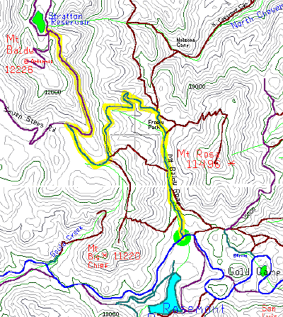
Location Map showing Frosty Park and Mount Baldy (Almagre Mountain)
Just in case readers feel that access to the site by hikers means that the sites are not all that hard to get to, they will be disabused once they see the rigors of getting to the access road. If you look at the next map (comparing to the first map), the turn-off to Frosty Park is off the road from Colorado Springs to Cripple Creek (called the Gold Camp Road below) and takes place just to the right of the d in Road in the figure below, where a little lake is shown to the south of the road on the map at the right (matching the detail in the first map).
The turn off occurs about 15 miles to the SW of Colorado Springs on the road to Cripple Creek, which is said to occupy the route of the former railroad to the gold mines:
"A hundred years ago Gold Camp Road was the railroad that connected Colorado Springs to the gold mines at Cripple Creek. Today, this secluded twenty mile stretch of road twists through some of the area’s most beautiful country".

If you google Cripple Creek, you will see much interesting local history of the gold camps in the late 19th and early 20th century.
To get to these sites from UCAR headquarters in Boulder, a scientist would not merely have to go 15 miles SW of Colorado Springs and go at least several miles along a road where they would have to be on guard for hikers and beware of scenic views, they would, in addition, have to go all the way from Boulder to Colorado Springs. While lattes would doubtless be available to UCAR scientists in Colorado Springs, special arrangements would be required for latte service at Frosty Park, though perhaps a local outfitting company would be equal to the challenge. Clearly updating these proxies is only for the brave of heart and would require a massive expansion of present paleoclimate budgets. No wonder paleoclimate scientists have been unable to update these records since Graybill’s heroic expedition in 1983.


40 Comments
THE HEROIC EXPEDITION! Send in DanO. He’s the only man who can get there. Who can carry that Message to Garcia…
I live about 10 minutes from Gold Camp road, and drove by it on the way to and from Breckenridge ski resort today. They can never seem to make up their minds whether or not we are allowed to travel it.
Mark
PS: another 9″ of snow on top of an already record season, must be GW!
Given the ease of access, could it be they already have the up to date core samples, but these sample do not show the right trend, ie negative response to rising CO2 and higher temps? No sense messing up the global warming message with some contrary data.
“Pat Frank thought that I was being a little sarcastic of the rigors of updating tree ring collections at Niwot Ridge.”
Not at all. I was truly admiring a wonderful display of irony (hence the emoticon), which was enjoyed throughout. Honestly, there was no criticism meant at all.
Following up, I’m impressed with the properly serious analytical demeanor to which you’ve returned here, Steve. And in that vein, I can offer the prior critical observations made back in 1969 by a group of Cripple Creek-local commentators.
The Almagre Road
Map
I actually looked at the lyrics before putting the post. The group that sang Up on Cripple Creek, The Band, was from Toronto http://www.canoe.ca/JamMusicPopEncycloPagesR/robertson.html and played in Toronto bars in the 60s when I was a teenager and early 20s.
Pat, did you follow the link at your URL to this amusing take on the eytmology of Cripple Creek in the song? http://theband.hiof.no/articles/up_on_cripple_creek_viney.html
#7 I didn’t see that, Steve, thanks. I did read the short biography of the band, “The Band,” though, where I learned for the first time of the Toronto connection. Good job, Canada.
I’d previously thought from their sound and look that they were purely Tennessee boys. Their picture sure conveys the slightly damp borderline sanity one might expect of a group from the backwoods piney mountains. I guess a fair amount of their initial inspiration came from there.
By the way, it’s possible to find very functional light-weight, backpacker-suitable espresso-makers these days, and so there’s no real reason why a UCAR proxy-corer should not be properly equipped for a dangerous trek. Opinion offered as a freely-admitted addict myself.
I’ve been a long-time secret admirer of ClimateAudit, but in this case I have a criticism. Mr. McIntyre, you correctly point out a problem with some paleoecologists, but you fail to suggest a constructive solution. This is where real leadership ability would come in handy. I am therefore recommending the following.
Edwin Louis Cole (2002), Courage: Winning Life’s Toughest Battles.
Osho (1999), Courage: The Joy of Living Dangerously.
John McCain (2004), Why Courage Matters: The Way to a Braver Life.
RE # 10 George W. Bush
“… but you fail to suggest a constructive solution …”
The problem can be seen as an answere to your question: There is no constructive solution because the connection to temperature is unknown !!!!!
If you know a connection to tree ring and temperature then tell us!
That is the main problem presently!
Cripple Creek kinda blows these days (uh, sorry for the overly technical language there). Nothing but a big gambling town… and the worst part, $5 betting limits. I mean, c’mon. 🙂
Mark
Now now, folks. That’s a harder hike than you may think!
A more detailed map shows this is inhospitable territory.
– The main mountain-top area is above treeline. No protection from wind and weather. Yet somehow one must maintain while performing complex core sample procedures.
– Wintertime, inaccessible due to snow/ice
– Summertime, access limited to mid-day due to severe danger of sudden storms, lightning, etc…
– 60mph winds are common.
Plus, the danger of altitude sickness and more.
Directions to the mountain can be found
here.
Best suggestion: set up a good base camp, allocating sufficient preparation and recovery time. This site has worked well in the past.
The Broadmoor would be a fine base camp to acclimate UCAR scientists for the hazardous trek up Almagre Mountain. (My sister is a landscape architect in Colorado Springs and I think that I recall that they did the landscaping for the Broadmoor, which I’ve definitely heard of before.)
In terms of preparing for the hazardous trek up Almagre Mountain – and it would not be all the way up this formidable peak as Frosty Park is at 10,555 ft) and the Almagre Mt bristlecoens at 11,565 ft., here’s some information on how long the "complex" coring might take, based on sampling at Campito Mountain and Sheep Mountain – see my post here
So our interpid explorers would have to prepare for an entire day at these formidable altitudes. I agree with you that altitude sickness may be a serious consideration. After all, the bristlecones are almost as high as La Paz, the capital of Bolivia (11,913 feet) – so even a day at these altitudes could be life-threatening without proper acclimatization.
Even the lower site of Frosty Park is over 400 feet (!!) higher than Leadville, Colorado (elevation 10,152 feet) said to be the highest city in the U.S. That additional 400 feet makes all the difference.
For very short intervals, I suppose that it would be safe to be at the altitudes of Frosty Park and the Almagre bristlecones. After all the Pike’s Peak marathon goes to the top of Pike’s Peak (14,110 feet) and back, but I doubt that the runners would be spending several hours above 11,0o0 feet. Of course, half a million people are said to visit the top of Pike’s Peak every year. But they are not climate scientists. I think that 2 weeks of preparation at the Broadmoor prior to the expedition and 2 weeks of winding down would be the minimum that would be medically safe for a UCAR scientist.
“My sister is a landscape architect in Colorado Springs ”
A candidate for tree/shrub ring analysis in the Colorado area?
Leadville is not the highest, Alma is. 10,578 feet above sea level. It’s on wiki, too (wiki says 10,355). I drive through it on the way to Breckenridge every other Friday to ski! 🙂
Mark
Oops… Alma is the highest “municipality”. Guess they haven’t struggled to become incorporated yet. Hehe…
Mark
You people are really being unreasonable here.
You have to do a full cost-benefit analysis to really appreciate Mann’s point. We are talking about THOUSANDS and THOUSANDS of dollars and many days of work to to do these cores and analyze them.
And what would we get for all this expense? Just a chance to get an out-of-sample verification of a theory that policymakers might base some treaties on. Big deal.
🙂
Ah, hell, Mr Pete, I used to hike in that area as a 14 year old tenderfoot Scout.
But Steve, you’re a little mistaken: you’d take 285 on through the Morrison Cut and head south past Fairplay. Going through the Springs is around 3 sides of a square.
(As an aside, that route takes you straight through South Park. Make of that what you will.)
#20. I think that Pete was teasing.
#20, as a 14 year old tenderfoot, my thyroid metabolism let me consume 8k calories of food a day and keep warm no matter where I was… it’s a bit different hobbling around at N x that age. We’re simply attempting to be realistic in creating a viable plan for NCAR staff to update the data. (Oh, and please check your map. It’s much shorter and quicker to travel via COS.)
Beyond that, I’m amazed that (#21) Steve would suggest I’m making light of a serious situation like this.
After all, isn’t the anticipated global outlay to ameliorate AGW in the US$109 to 11 range? As #18 says, can we really afford to be so profligate as to invest scarce resources (US$210 to 12) on further validation, rather than just getting to the task at hand?
Oh… and remember, they need to acclimatize for the work and do some team-building at the recommended base camp, so they’ll be going to the Springs anyway.
RE: #10
With all due respect, Mr. President, in my humble opinion, there is a time for the Dale Carnegie approach which I know you strongly favor, and, there is a time for the Josie Wales approach. For everything, turn, turn, turn, there is a season…. etc. 😉
Inspired by recent “amateur audits” of Stevenson Screens: how hard would it be to empower a legion of volunteers with the ability to retrieve useful core samples?
But … the frigid alpine temperatures … the distances … all that heavy equipment … IT’S NOT POSSIBLE!
Hmmm… tree coring does use weighty equipment. The coring tool alone must weigh at least 2,500g!
You’re right, bender. What was I thinking?
Obviously, it takes a village. And not just a group of volunteers. Multinational teams with government sponsorship. Time to activate the email legions.
MrPete,
Just what is the purpose of getting tree cores when one is above the treeline?
Re #29
MrPete,
The situation is far graver than you suggest. I believe the equipment you describe weights at least 2.5 MILLION mg!
Will need caches, C130 airdrops, base camps …. 😉
I think that you mean 2.5 milllllll-yun mg. BTW if anyone know how to make custom smileys, I would recommend that we acquire a little Dr Evil smiley for inclusion in such circumstances. A CA reader started doing this for me and cropped a Dr Evil photo, but we got stuck at making the smiley.
Re:#28 bender,
Not possible, but plausible.
#30 (seriously) dendro “signals” are best under stressed conditions, so trees at treeline are potentially ideal.
The top of Pikes Peak is useless but Colorado has an extensive treeline.
#35,
I can understand getting cores at the treeline. It was just that I was concerned about the efficiacy of trying to extract cores when one is above the treeline.
Question: Suddenly finding small small oaks, 30-40
centimeters high I guess high above treeline on south/
western slopes in the Swedish mountains (Source: Leif
Kullman UmeॠUniversity he says it shows GW… surprise,
surprise!!!)is this news or???
RE: #37 – are the oak bushes / trees amongst other scrub type vegetation?
Read up on tree line… it isn’t really a sharp dividing line.
It’s simply the general edge of hospitable climate. Microclimates can exist above “tree line” that support tree growth in various ways.
Nature rarely provides sharp Yes/No divisions.
There is a certain undue snideness to the posts on this subject.
As we know from the “The Mysterious Taylor Dome Borehole” thread, collecting the data is trivial. Analyzing the data, especially now that the field is fraught with “auditors” is the problem. First one must learn how to normalize data, something about r squares (geometry?) and t-statistics (shirts?). This is the heavy baggage (not just equipment) that one must carry when updating the work.
Besides, the data would be proprietary because of the confidentiality agreement necessary to compute the teleconnection with the weather in Heidelburg.
#37-39…
Another Kullman in biggest Swedish morning paper
“Dagens Nyheter” Daily News link http://www.dn.se/DNet/
jsp/polopoly.jsp?d=597&a=452734&previousRenderType=8
It basically tells us that “Tandövala” in early 20th
century was a bald mountain although peak height of
only 774 meters ASL …Kullman mixes forrest-line
and tree-line up, doesn he? In another article
in “Natur” Swedish Environmental Preservation Association
or shortly “SNF” in swedish a Jan Sundquist tells us that
according to some scientists the forrest now comes back after
19th or 18th century fires natural and/or man-made..Charcoal
was made in “milor”…Yes what would you say folks??
Actually I phoned Kullman up in August 2005 and asked him about
another real bald mountain “Städjan” (North peak 1131m,
S peak 1050?m WIKIPEDIA)(Use Altavista to
see pictures from)which he claimed to have some pines
just under the top… No
photos though these guys are trustworthy…He was very
“airy” so he didn say anything, avoiding is the word!
#41, I believe Tandövala is at around 60 50 10 N x 13 10 28 W ?
Google earth gives approximately the altitude you gave for that area, and shows that there is some kind of “tree line” below 1000m around there. Yet something else is likely involved. Many factors affect growth.
I’d be more impressed by a historical comparison in a place that has a better defined treeline, and is more rural. For example, Sylarna is further north (63 degrees) and should have an even lower tree line based on climate. Yet the nearby mountain range gives a better sense of the treeline in that part of the world…generally well above 1000m — more like 1300m.
One Trackback
[…] testing of the proxies used in MBH99, Crowley and Lowery etc – especially the bristlecones.I’ve continued to satirize this failure pointing out that several of Graybill’s classic bristlecone sites were easily […]